
A Colorado River Water Primer
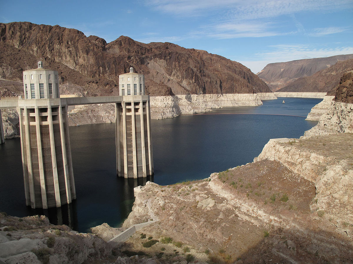
Image: Lake Mead is now less than half full (courtesy of Wikipedia Commons)
__________________________________
A good number of my friends and colleagues have complained that my recent blogs about the Colorado River have been too wonky, too geeky. “They’re boring.” “They’re incomprehensible.”
That has inspired me to break it down. Simplify. Create a primer. Here we go!
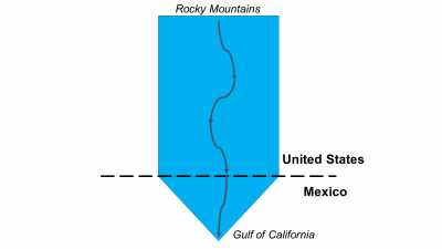
This is the Colorado River Basin. It provides water for 40 million people including those living in Los Angeles, Phoenix, Las Vegas, Denver, and others. It irrigates 5.5 million acres of farmland in the US and Mexico.
The basin has historically provided habitat for 33 native fish species including one that has been there since the river began carving the Grand Canyon.
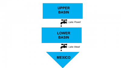
This is how water professionals view the river.
Nearly 100 years ago (in 1922), a group of ‘water buffaloes’ wrote a rulebook (the Colorado River Compact) that allocated the river’s water among seven states. The ‘Upper Basin’ states of Colorado, Utah, New Mexico and Wyoming were given 7.5 million acre feet (MAF) per year. The ‘Lower Basin’ states of California, Arizona and Nevada got the same amount: 7.5 MAF/year. Twenty-two years later, the water buffaloes gave Mexico some water too: 1.5 MAF/year. The fish are still waiting for their water allocation.
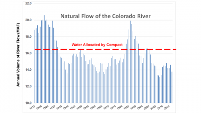
Inconveniently, the river doesn’t always produce the 16.5 MAF of water that the water buffaloes gave away in 1922 or 1944. To understand how they made this mistake you’ll need to read this book. Let’s just say: ruh-roh.
That mistake wasn’t such a big deal when there weren’t many people using the river and when the climate was ‘normal.’ But then the desert bloomed with irrigation and the cities swelled and the climate warmed, drying up the river.
More than half of all the water goes to irrigating cattle feed crops. Another one-fourth goes to other crops. Cities and industries take the last quarter. Not a drop flows into the Gulf of California anymore. Twenty-two of the 33 native fish species are now imperiled or extinct.
See that right side of the natural flow graph above? Since 2000, the river’s produced only about 14.5 MAF on average. Some really smart climate scientists say that’s because the climate’s not normal anymore, and the river will be drying more and more each decade. Double ruh-roh.
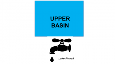
The people that use water from the Upper Basin figured they were going to be OK for a really long time because they have been consuming only about half of their water allocation each year.
But it turns out that their own water buffaloes didn’t cut such a great deal when the Colorado River Compact was being written. Most scholars (excluding lawyers) assume that the Upper Basin is on the hook to deliver an average of 8.23 MAF/year to the Lower Basin (7.5 MAF for the Lower Basin plus half of Mexico’s share) – no matter how much the upper river is producing. With the river drying up that’s getting harder and harder. Ruh-roh.
Compounding this problem is the fact that the federal managers of the big reservoirs – following their own rules that nobody really seems to understand — have been releasing a lot more than 8.23 MAF/yr from Lake Powell in the Upper Basin, draining the lake in the process. Since 2000, they’ve averaged releases of 8.83 MAF/yr and the lake has lost an average of 0.6 MAF each year. It’s now only half full.
If the lake drops to a critically low level – all it would take is a few years as dry as 2001-2005 — the Upper Basin simply won’t be able to physically release that required 8.23 MAF from Lake Powell. They’ll be in violation of the Compact. Double ruh-roh.
To come into hydrologic balance and remain compliant, the Upper Basin is going to have to negotiate new rules for the federal reservoir managers and keep their current level of use from growing. If only the required 8.23 MAF/yr was being released, Lake Powell would now be full.

Those using water from the Lower Basin have benefitted royally from those higher-than-mandated releases from the Upper Basin. It has enabled them to use a lot more water than they were allocated in 1922. At their peak they were consuming as much as 8.4 MAF, and Lake Mead was evaporating another 0.5 MAF/yr. Ruh-roh.
Since 2000, the Lower Basin has tightened its water belt and averaged 7.5 MAF/yr of consumption – exactly what it was allocated. But with Mead’s evaporation – never accounted for in the Compact allocations – and the requirement to share water with Mexico, the lake has lost nearly 60% of its capacity. Double ruh-roh.
To come into hydrologic balance, the Lower Basin is going to need to reduce its consumption by 18% from its 2000-2018 average. The best way to do this is to pay farmers to grow water.
Class dismissed.
Oh, I do wish you would refer to it as the Gulf of California. It’s the name used in science and it’s less offensive to Mexicans who don’t care to honor Cortez.
My (stupid) mistake, Tricia, and thank you for pointing that out. Reminds me of Neil Young’s song “Cortez the Killer.” I’ve corrected this on the blog on my website: https://www.sustainablewaters.org/a-colorado-river-water-primer/
Great comment. Glad you are focusing on the point of this article. Your comment really helps solve the imminent and relevant water issue.
Brian: These report are not too geeky or wonky. They are very good. I especially like the figures. Thanks for this. I will suggest that these allocations-folks weren’t actually “water buffaloes” but “water buffalo hunters”. “Buffalo hunters” was the term our resource managers (fisheries) used to use in British Columbia as a descriptor for “olden time” unsustainable mass extraction/harvest of a particular species or stock of fish under earlier harvest regulations (mostly up-until the 1960s’ or 1970’s). I enjoy getting these summary “stories” as they have application to some of the water work I am involved in here in BC. Marvin Rosenau
Hi Brian
I really enjoyed this – thanks. The last line “To come into hydrologic balance, the Lower Basin is going to need to reduce its consumption by 18% from its 2000-2018 average” is asserted with no reference or link. Can you point me to details of this assessment? And what assumptions does this assessment make with respect to climate impacts on flows? You point out there is an ongoing long-term decline in flow, so surely achieving a “hydrologic balance” will require a long-term decline in withdrawals.
Bill, I’ve not yet found anywhere else that has pegged the overuse at 18%, so this calculation is my own. You are absolutely correct in suggesting that under climate change, that figure would increase as the river flow dwindles in the future. Thank you for emphasizing this!!
HI Brian, I use the Colorado River as an case study for my undergraduate and postgraduate students in Australia. Thank you for the clear summary for those of us who have been watching the management of this system from afar.
Glad it’s been useful to you, Robyn! And we have a great deal to learn from the Australian experiences in the Murray-Darling Basin!!
Thank you — this is a great piece of writing and analysis and we need more writing like this to explain water and water issues. I plan to have my community college class read this!
Brian, Thanks for your summary, So, if I read this correctly, between allocations of !6.5M AF and evaporation At Powell and Mead of 1.1M AF, there is a total annual “demand” on the River of 17.6M AF, while the present day annual flow is more like 14.5M AF, creating a shortfall of approximately 3M AF per year. Is that right?
Yes, Jeremy, that math would be correct IF the Upper Basin water user were consuming all of their 7.5 MAF of allocation. However, the Upper Basin has been using only ~3.9 MAF on average, which is a major reason why Lake Powell would presently be full if not for the releases of >8.23 MAF.
Excellent summary. I forwarded to some of my geo and non-geo friends . Professor Richter is this going to be on the test?